Groundwater Depletion Stresses Majority of World’s Largest Aquifers
Scientists do not know how much groundwater is left.
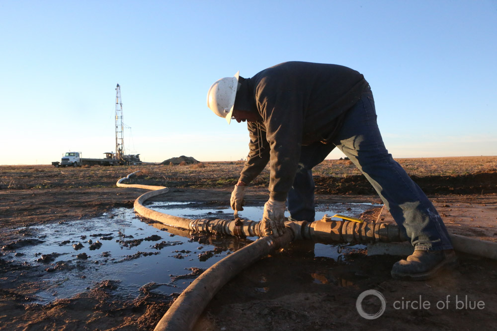
Hydro Resources drills a well near Sublette, Kansas. The Ogallala Aquifer provides nearly all of the irrigation water in the High Plains, one of America’s top grain regions. The Ogallala is being depleted in Kansas, and some areas have only a few decades of water remaining. Click image to enlarge. Photo © Brian Lehmann / Circle of Blue
By Brett Walton
Circle of Blue
Population growth and agriculture are putting unsustainable demands on the world’s largest aquifer systems, particularly those in the planet’s dry midsection, according to the broadest assessment to date of global groundwater-storage trends.
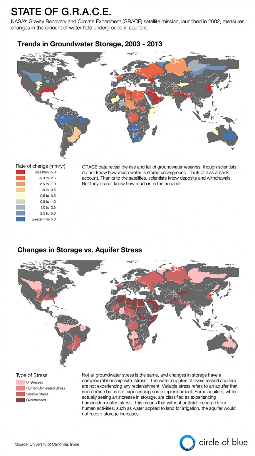
Water reserves in 21 of the 37 largest aquifers have declined since 2003, according to a study led by researchers at the University of California, Irvine, who analyzed data from NASA’s GRACE satellite mission. Moreover, 13 of the aquifers are depleted to the point that regional water availability is threatened.
“We don’t really know how much groundwater we have.”
–Jay Famiglietti, professor
University of California, Irvine
More than 2 billion people rely on aquifers as their primary water source. The water held underground in layers of rock and soil is an essential emergency supply during droughts, when rivers and streams shrivel, as is the case today in California. Too much groundwater pumping can cause rivers to dry up, the land surface to sink, and wetlands to evaporate.
Key groundwater basins on every inhabited continent are being drained, according to the study.
From northern China to the Middle East, from North Africa to the Central Valley of California, a common and unsettling story is unfolding: the effort to produce massive grain and food surpluses that will feed billions and to supply drinking water to the largest knots of humanity on the planet is taxing aquifers beyond their capacity.
Yet despite groundwater’s prominence, surprisingly little is known about the size of reserves, according to a separate study accompanying the analysis of GRACE data that points out the rudimentary state of scientific knowledge about aquifer storage. The two studies were published online today in the journal Water Resources Research.
“We don’t really know how much groundwater we have,” Jay Famiglietti, a co-author on both papers, told Circle of Blue. “It’s something scientists have been talking about for a long time, but it needs to be said clearly.”
The lack of knowledge — due to the cost and complexity of groundwater-monitoring systems — is unacceptable, Famiglietti said. Acquiring the information necessary for a fully formed understanding of the world’s water resources requires a concerted effort that places the value of water on par with the earth’s wealth of minerals and fossil fuels.
“We need to embark on a major hydrogeological exploration of the world’s aquifers,” said Famiglietti, a professor of Earth System Science at the University of California, Irvine, and senior water scientist at NASA Jet Propulsion Laboratory. “I don’t see how we can get around it. We need to explore the world’s aquifers as if they were oil reservoirs.”
Stocks and Flows
The studies bring together two aspects of groundwater that are rarely considered together: the flow of water into and out of an aquifer and the stock of water sitting underground.
A bank account is a common analogy. An account holder must know both deposits and withdrawals (the flows) and the account balance (the stock).
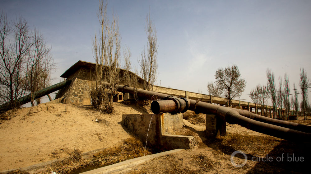
An irrigation system in Ningxia, China. The groundwater resources on the North China Plain are slowly being drained. Click image to enlarge. Photo © J. Carl Ganter / Circle of Blue
The GRACE satellite mission, which launched in 2002, is helpful for assessing flows. The pair of satellites translates changes in the Earth’s gravitational field into changes in water storage — water being so heavy that it alters gravitational pull.
GRACE will detect changes in the total amount of water that is stored underground, a measure that incorporates both human withdrawals — for irrigation, household use, or mining — and natural variations due to drought or flood. Water withdrawal statistics, compiled by local or national agencies and a typical source of information for researchers, do not provide such a full picture.
“Traditional use statistics show withdrawals only,” said Alexandra Richey, lead author of both studies. “But all factors have to be at play when considering groundwater sustainability.”
According to the study, which used data from 2003 to 2013, the three basins with the highest depletion rates cover a variety of ecosystems and manmade pressures:
- Depletion in the Ganges Basin, in northern India, is fueled by dense cities and expansive irrigated fields.
- In the Arabian Aquifer, which underlies Saudi Arabia and several other Gulf nations, irrigated agriculture is the primary stressor.
- In the Canning Basin of northwest Australia, the mining industry is the biggest groundwater user.
Balancing the Check Book
In 1904, the Texas Supreme Court concluded that groundwater was too “secret, occult, and concealed” to regulate. More than a century later, knowledge about the account balance in most of the world’s aquifers is little better than in the early days of the automobile.
According to the study on groundwater stocks, commonly accepted estimates of groundwater storage have little relationship to actual conditions. Estimates developed in 1969 and 1974, which are still cited today, assumed that each aquifer had the same characteristics, that the depth to water and the water-holding capacity of the soil were the same. They are not.
By altering the assumptions of those original studies, based on findings from regional groundwater studies — which are smaller in scope but have more detailed information on local conditions — the research team found a much emptier balance sheet.
“We have less groundwater than we thought,” Famiglietti said. “A lot less.”
The regional estimates were between 10 and 1,000 times lower than the rough estimates from 40 years ago, an astonishing difference.
Knowing how much water an aquifer holds is important for understanding its resilience to periods of depletion.
A large storage capacity allows for more pumping before the aquifer is drained. The study draws a comparison between two aquifers in North Africa — the Nubian and the Sahara. Both have similar rates of depletion, according to GRACE data. But the Sahara has roughly 10 years until 90 percent of the water is gone, according to the lowest storage estimate. The Nubian has 13,000 years of water, according to its lowest estimate.
There are several limits to the analysis.
First, GRACE data express average conditions across a large expanse of land. Significant variations, both in water levels and water use, within an aquifer are blurred. The Ogallala Aquifer, in the U.S. High Plains, is one example. GRACE data show a net increase in water storage in the Ogallala. That is entirely due to gains in the northern half of the Aquifer in Nebraska. Parts of the Aquifer’s southern end — in Kansas, Oklahoma, and Texas — have only a few decades of usable water left. On the aquifer’s margin, the water has already run out.
Second, the GRACE satellites can measure only one dimension of water: the quantity. Other physical attributes such as pollution, or economic factors such as the cost of pumping from increasingly deeper depths, are beyond the mission’s purview. Arsenic pollution or extremely deep reserves that are expensive to pump would, in effect, decrease the amount of available water in an aquifer.
Next Steps
The old, rudimentary estimates of groundwater storage have persisted not because of a lack of interest, Richey said. Other factors are at play.
“Aquifers are hard to study,” explained Richey, whose doctoral dissertation is based on the research in the two studies. “You need to drill wells and get ground-based measurements. That’s expensive and requires a lot of wells. The oil industry does it because there’s a lot of money in oil.”
Of the dozens of regional studies that the research team looked at, Richey could recall only one, in the Ogallala Aquifer, that used observational data rather than estimates to assess aquifer storage.
Richey thinks that groundwater could be the perfect opening for citizen science, a public data-gathering program. After all, millions of wells are already operating, pumping water for homes, businesses, and crops.
“In my dream, there is a common platform for groundwater users to upload their groundwater information,” she said.
Brett writes about agriculture, energy, infrastructure, and the politics and economics of water in the United States. He also writes the Federal Water Tap, Circle of Blue’s weekly digest of U.S. government water news. He is the winner of two Society of Environmental Journalists reporting awards, one of the top honors in American environmental journalism: first place for explanatory reporting for a series on septic system pollution in the United States(2016) and third place for beat reporting in a small market (2014). He received the Sierra Club’s Distinguished Service Award in 2018. Brett lives in Seattle, where he hikes the mountains and bakes pies. Contact Brett Walton





Stopping of deforestation and planting of trees are an answer to the continued depletion of ground water.Without trees, rain water get evaporated due to hot.
No, excessive water usage is the main contributor. Root watering, water recycling and change of habbits would decrease usage. Water-hungry korn and alfa-alfa agriculture too feed livestock is a luxury dry areas cannot afford, consider decrease meet consumption. Hard regulatory limits on water use are needed. And California should stop growing almonds! But I’m afraid most countries will not act until its definitively too late USA is using loads of fresh water for fossile gas and oil fracking.
Overpopulation is the primal driver. Even with population balanced with resources we would need conservation and pollution controls, but for any solution to have any chance of saving our bacon we have got to find a way to not only stop increasing human population but to find a humane approach to reducing total human population.
I agree Dreighton, we should just snap half of the planet away with the stones like Thanos did in the movie. This is what he was trying to warn us about. Smh dumb Avengers.