By Kaye LaFond and Codi Kozacek
Circle of Blue
After five years of civil war, the humanitarian crisis in Syria has reached massive proportions: More than 4.6 million people have fled the country as refugees, and at least 7.6 million more are internally displaced within Syria, according to aid agencies. The disaster, while complex and multi-faceted, was likely triggered in part by a severe drought preceding the conflict, scientists said in a study published last year in the Proceedings of the National Academy of Sciences.
Outright conflict over water is rare, and history has shown that communities and nations are much more likely to cooperate over water than to fight, according to leading researchers. But as climate change, population growth, and industrial development put strain on water resources around the world, water issues can join with social and political upheaval to destabilize vulnerable regions.
The Syria conflict is an extreme example, but water supply issues could also contribute to other types of severe humanitarian crises, such as famine or forced migration. Water-scarce regions are particularly vulnerable — the Horn of Africa, for example, where droughts are often linked to chronic food insecurity. But water-rich areas can also be at risk. Brazil has extensive freshwater resources, but it contends with water supply issues in its megacities, threatening a major crisis if a city like Sao Paulo were to run dry.
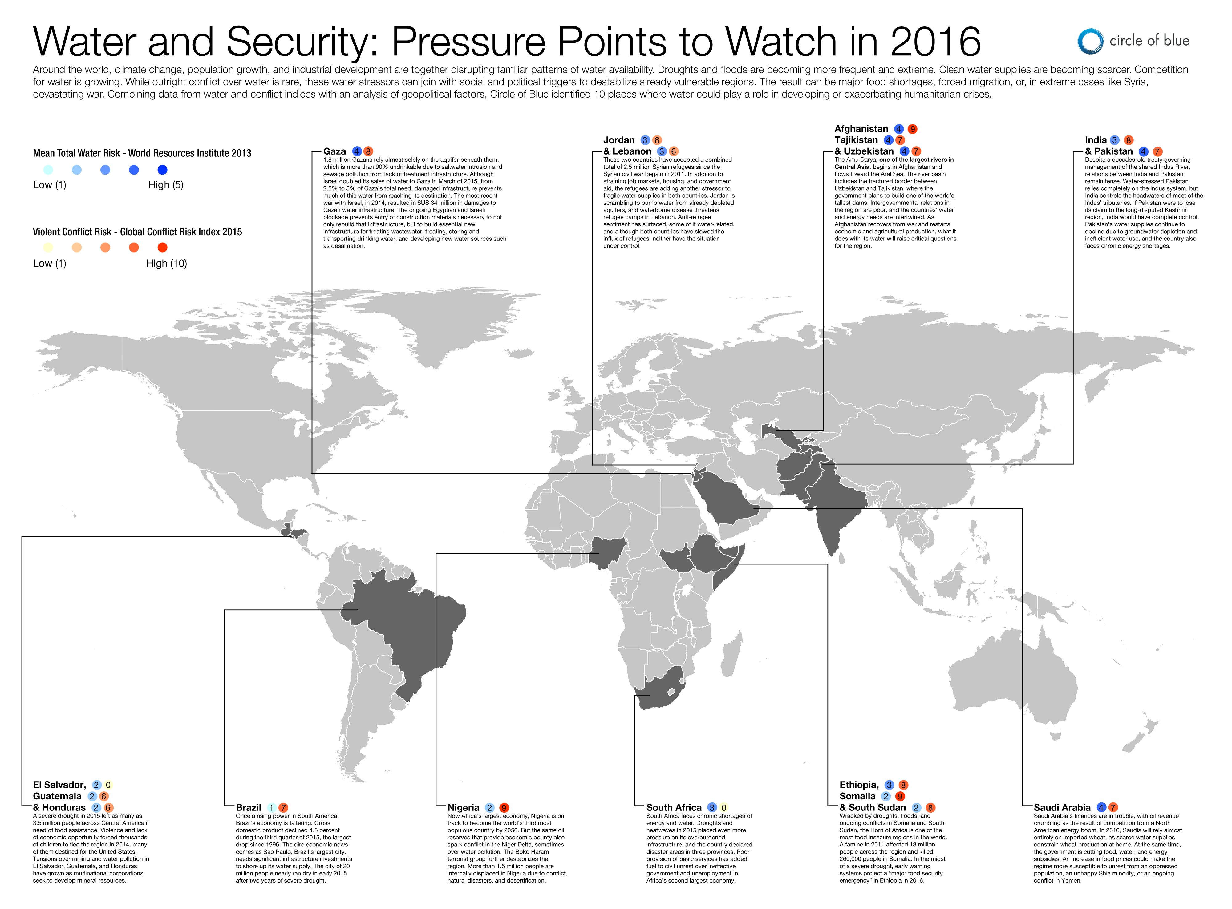
Water problems in themselves are not enough to create a conflict, famine, or mass migration. Places like California and Australia, despite severe and lengthy droughts, have the institutional capacity and resources to manage and contain water crises. Other regions do not have the resources or the capacity to do so. Combining data from water and conflict indices with an analysis of other geopolitical factors, such as dependence on food imports and the presence or absence of effective water management systems, Circle of Blue identified 10 places where water could compound existing social stressors and contribute to a humanitarian crisis.
The ten areas identified by Circle of Blue’s analysis include:
- Afghanistan, Tajikistan, and Uzbekistan
- Brazil
- El Salvador, Guatemala, and Honduras
- Ethiopia, Somalia, and South Sudan
- Gaza
- India and Pakistan
- Jordan and Lebanon
- Nigeria
- Saudi Arabia
- South Africa
Circle of Blue took into account both the Aqueduct Water Risk Atlas, created by Washington, D.C.-based World Resources Institute, and the Global Conflict Risk Index produced by the European Commission’s Joint Research Centre. WRI’s water risk index, published in 2013, considers water quality and water quantity in the domestic, agricultural, industrial, and ecosystem contexts. The GCRI calculates the likelihood of a conflict breaking out in a given area, as well as how intense the conflict might be. It is updated every six months.
is both a scientist and a journalist, she holds an MS in Environmental Engineering from Michigan Technological University, and she brings proficiency in ESRI’s ArcGIS mapping software.
Related
© 2023 Circle of Blue – all rights reserved
Terms of Service | Privacy Policy


