Map: Sao Paulo Water Supply Systems
Drought has placed Sao Paulo’s Cantareira water supply system under extreme stress.
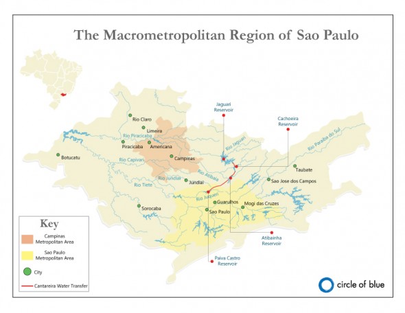
Map: The Cantareira reservoir system transfers water from the Piracicaba, Capivari, and Jundiai river basins to supply the vast metropolitan region of Sao Paulo. This map shows the four main reservoirs that make up the Cantareira system. Five other reservoir systems also supply Sao Paulo. Click image to enlarge. Map © Codi Kozacek / Circle of Blue
Failed rains and the water demands of 20 million people have collided to create the worst water crisis on record in Sao Paulo, Brazil’s largest city. Sao Paulo is perched on a plateau, more than 700 meters (2,300 feet) above sea level on Brazil’s eastern coast. The city is at the headwaters of the Alto Tiete Watershed, which — like all other rivers in the region — runs toward the country’s interior. This means that there is not as much water in the metropolitan area as there is further downstream. The city’s remedy is to pump 33 cubic meters (8,700 gallons) of water per second back upstream from the Piracicaba, Capivari, and Jundiai river basins through the Cantareira water supply system—a network of 48 kilometers (30 miles) of tunnels and six reservoirs. It also relies on five smaller reservoir systems that source water from within the Alto Tiete Basin.
In lieu of water rationing, Sao Paulo has decided to manage its severe drought by spending millions to tap the deepest pools of its drained reservoirs. The risky move has put leaders of one of the world’s largest water utilities under a global media microscope, and invited harsh criticism from some hydrologists and politicians.
A news correspondent for Circle of Blue based out of Hawaii. She writes The Stream, Circle of Blue’s daily digest of international water news trends. Her interests include food security, ecology and the Great Lakes.
Contact Codi Kozacek








A proposal to deliver large volumes of fresh water from off-shore locations near the mouth of the Amazon River to Sao Paulo using large waterbags connected into long trains has been presented to Sao Paulo water officials. See: http://www.youtube.com/watch?v=4TEJp6UZaDI for a YouTube video of television news coverage of a demonstration of waterbag technology in Washington State. More information can be found in a Wikipedia article at:
http://www.en.wikipedia.org/wiki/Flexible_barge.