Rising Seas Threaten Tens of Millions More People with Inundation, Study Says. Even That May Underestimate the Impact
Study does not account for water-use practices that worsen local sea-level rise by eroding and compacting the land.

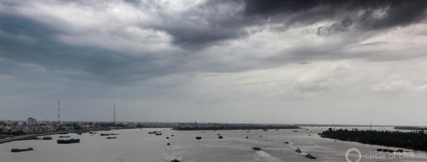
Clouds darken the sky off of Vietnam’s southern coast, near the Mekong delta. Photo © J. Carl Ganter / Circle of Blue
By Brett Walton, Circle of Blue
Using updated estimates of coastal elevations, a new study shows that more than three times as many people than previously thought are currently living in areas at risk of being under water during high tide in the second half of the century.
The study reckons that 110 million people today live in these coastal zones that are threatened with inundation at high tide in the coming decades, up from earlier estimates of about 28 million people.
The increase in the number of people vulnerable to sea-level rise, most of whom live in eight Asian countries, results from more precise mapping.
“We find that the global impacts of sea-level rise and coastal flooding this century will likely be far greater than indicated by the most pessimistic past analyses relying on [space shuttle-based measurement],” write Scott Kulp and Benjamin Strauss, researchers with Climate Central who developed a new computer model to depict the elevation of coastal land.
A new model was necessary because high-quality coastal land elevation measurements are available for only a few areas: mainly Australia, Europe, and the United States. The accuracy in these places is due to widespread use of lidar, a remote sensing technology that employs laser pulses to draw an accurate map.
Lidar measurements are not as widely available for the rest of the world, where less accurate, space shuttle-based instruments have been used to gauge land elevations. These instruments sometimes mistake buildings and trees for the ground, resulting in land being depicted at a higher elevation than it is in reality. The error in the United States was more than 3 meters (10 feet), on average, when compared with lidar measurements. In short, the old method ended up underestimating the people and places that are at risk.
A more accurate map of the rest of the world, particularly the Asian coast lines, is essential for forecasting the consequences of rising seas because that is where some of the greatest vulnerabilities are.
Exposure to rising seas is set to grow. The oceans expanded in the 20th century, but only modestly. Estimates, averaged globally, range from 11 to 16 centimeters (4 to 6 inches).
This century the process will accelerate. Just how much depends on the amount of carbon dumped into the atmosphere. On the low end, the seas might rise a half meter (19.7 inches) by 2100. If emissions continue to climb substantially and Antarctic ice sheets destabilize — currently a low-probability scenario — then 2 meters (6.5 feet) or more might be in store.
In the Climate Central study, which was published in the journal Nature Communications, the researchers used datasets on vegetation and urban characteristics to train computers to identify the true lay of the land. That elevation model was then combined with population data and emissions forecasts to estimate the number of people threatened under optimistic and pessimistic scenarios in 2050 and 2100. The population at risk was based on the number of people who live in those places today.
Seventy percent of people currently living on threatened land live in eight Asian countries: China, Bangladesh, India, Vietnam, Indonesia, Japan, Thailand, and the Philippines.
Though the study provides more accurate mapping, it is not a comprehensive assessment of coastal risk. One such component is relative sea-level rise, which is the interaction between water and land. In some regions, the land is rising because it no longer has a glacial collar to weigh it down.
The areas of concern, however, are where land is sinking. If coastal zones are compacted or eroded and their elevation declines, even a small sea-level increase may produce relatively large consequences for the people who live there.
The Climate Central study did not account for relative sea-level rise. It assumed that land elevations remained constant. In the dynamic world, that is not the case.
Some of the most dramatic land alterations are a result of local and regional water use. Locally, groundwater pumping can cause the land to compact, lowering its elevation. This subsidence is occurring in coastal megacities across Asia, including Bangkok, Dhaka, and Jakarta, where a sea wall protects land that is already below sea level.
Regionally, structures meant to tame and harness flowing water can disrupt land-building processes. Dams trap sediments that would flow downstream to nourish deltas, which act as a bulwark against incoming tides. Levees, like those on the lower Mississippi River, funnel sediments out to sea where they disperse instead of anchoring new land.
Dams in the upper reaches of the Mekong River watershed are slowly starving the delta of its raw material and leaving it susceptible to erosion. Other studies warn that the delta, like others before it, is reaching a “tipping point for sustainability,” because of sinking land, trapped sediment, erosion, and sea-level rise.
The authors note that urban populations, because of hard infrastructure like sea walls, might be less susceptible to the forces of erosion or disappearance of wetlands, which are difficult to model. They also acknowledge that significant information gaps exist. That is why they call for collecting data on the location, height, and condition of levees and sea walls. Even today, people in New Orleans and the Netherlands live below sea level, protected by walls and dikes. Many more people in poorer countries do so unprotected.
It is with an eye to the unprotected and inadequately defended that Kulp and Strauss completed this work. Clearer assessments, they argue, show the benefits of avoiding additional emissions and identifying areas in need of better preparation.
“If our findings stand, coastal communities worldwide must prepare themselves for much more difficult futures than may be currently anticipated,” the authors conclude.
Brett writes about agriculture, energy, infrastructure, and the politics and economics of water in the United States. He also writes the Federal Water Tap, Circle of Blue’s weekly digest of U.S. government water news. He is the winner of two Society of Environmental Journalists reporting awards, one of the top honors in American environmental journalism: first place for explanatory reporting for a series on septic system pollution in the United States(2016) and third place for beat reporting in a small market (2014). He received the Sierra Club’s Distinguished Service Award in 2018. Brett lives in Seattle, where he hikes the mountains and bakes pies. Contact Brett Walton





Leave a Reply
Want to join the discussion?Feel free to contribute!