Building Bigger Walls in San Francisco Bay to Hold Back Rising Waters
Rising seas and a better understanding of flood risks prompt shoreline communities to build higher levees.
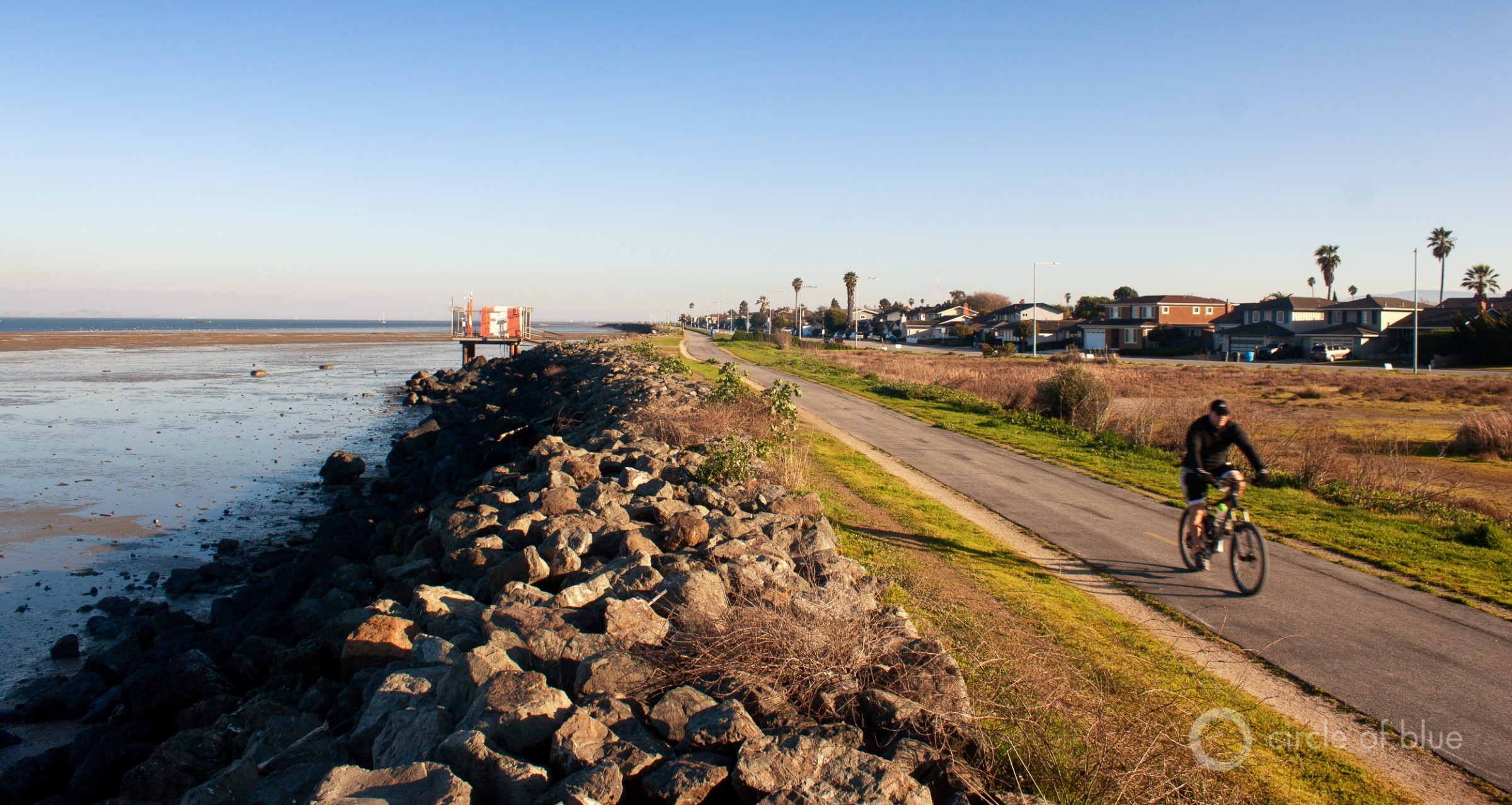
The multi-use Bay Trail extends along the levee that protects Foster City, California from flooding. The city is in the process of raising the levee. Photo © Brett Walton/Circle of Blue
By Brett Walton, Circle of Blue
FOSTER CITY, California — Six miles of mounded rock and earth already partially encircle this Bay Area city some 20 miles south of San Francisco. The levees protect about 17,000 parcels of land here and in neighboring San Mateo from waves, tides, and flood waters.
Those earthen embankments, however, are not protective enough. Not for floods today and not for floods of the future.
Spurred by a recent change in federal flood zone maps and a desire to prepare for rising seas, Foster City is in the process of raising its levees by 1 to 7 feet. Residents voted in 2018 to tax themselves in order to pay for the estimated $90 million upgrade.
When the project breaks ground later this year, the city of 35,000 people will vault to the forefront of urban adaptation in the Bay Area to rising waters. Guarding the region’s pricey real estate, high-volume rail and highway corridors, and millions of people from floods has soared in political importance in recent years.
The shift is marked by regional collaborations between state agencies, cities, and counties, the revival of an Assembly select committee on sea-level rise, and the willingness to levy new taxes like those in Foster City.
City leaders are aware of their responsibility.
“This is certainly the most important project for Foster City to protect our residents and businesses from damage to them and their properties from possible sea-level rise,” Catharine Mahanpour, the mayor, told the Assembly sea-level rise committee at a public meeting on February 7.
How Much Sea-Level Rise?
Foster City was compelled to act following a review of Bay Area flood maps by the Federal Emergency Management Agency.
The new maps were finalized in 2019 and incorporate better data on tides and water levels in the bay. The analysis that informed the maps found that Foster City and other municipalities have higher flood risks than previously thought. Those changes, which FEMA notified the city about in 2014, had consequences.
Unless it acted to reduce the risk, all of Foster City would have been placed in the flood zone, a move that would have required property owners with a federally backed mortgage to buy flood insurance for the first time.
The new flood maps represented an enormous shift for Foster City, but one based on sound reasoning, city officials said.
“We didn’t fight FEMA,” Norm Dorais, the public works director for Foster City, told Circle of Blue.
The city instead got to work. Officials asked FEMA to temporarily exclude the city from the flood zone while levee improvements could be drawn up and project funding secured.
Because FEMA would not accept indefinite delay, there was no time to wait for federal assistance. A bond measure that was put to voters in 2018 passed with more than 80 percent support. It was in voters’ financial interest to do so. The city estimates that annual flood insurance payments would have totaled $2,000 to $3,000 for an average household. Parcel taxes to repay the bond will be about a tenth of that amount.
Dorais said that the heights of the extended levees are based on two factors. One is FEMA’s new flood maps, which depict the risk of a flood that has a 1 percent chance of occurring today. The levees, at a minimum, had to provide that amount of protection. The other factor is sea-level rise, which will affect the bay as well as the ocean. On top of the protection mandated by FEMA, the city accounted for 2 feet of sea-level rise in the levee height.
Individual levee segments will vary in height depending on wave action in the bay. Choppier waters require higher walls.
Dorais told Circle of Blue that the city chose the 2-foot sea-level rise measure based on a 2018 guidance document from the California Ocean Protection Council, a state agency. That document estimates that there is a one-in-200 chance that water levels in San Francisco Bay rise more than 1.9 feet by 2050.
The levee project was designed with those numbers in mind. But then the guidance changed.
The Ocean Protection Council approved a new planning document on February 26, some six weeks after Foster City received its final permit for the levee project. The council now says that its target is to plan for 3.5 feet of sea-level rise by 2050.
Dorais acknowledged that changing sea-level projections are challenging for cities that need to make a decision today.
“We obviously can’t be continuously revising our design,” Dorais said.
Similar projects that abut the bay are running into the same quandary.
San Francisco International Airport is in the preliminary design stage of a $587 million levee-raising project of its own.
The airport also wants to be removed from FEMA’s flood zone, as well as provide for long-term protection against rising waters for its 8 miles of shoreline. It is building 3 feet of sea-level rise into its levee design, said Joe Birrer, the airport’s director of engineering.
“This is such a dynamic and fluid situation with the science,” Birrer told Circle of Blue. “This is problematic for us — we have to make a decision and plan around what we want to do. It’s a long process for approvals and permits.”
Birrer said that at this relatively early stage of the permitting process, the airport’s levee design could be increased by a half foot, if necessary.
Uncertainty about future sea-level rise is why Foster City was required to file an adaptation plan for post-2050. Those plans, which will include actions to further reduce flood risks, will be revisited and updated every five years, Dorais said.
A Bay-Wide Response
Foster City is not the first Bay Area city to recognize shoreline vulnerabilities.
San Francisco voters approved a $425 million bond in 2018 to begin strengthening the Embarcadero sea wall.
Built a century ago, the three-mile sea wall wraps around the northeast corner of the city, from the tourist strip of Fisherman’s Wharf to Oracle Park, home stadium of the Giants baseball team. The bond is just a down payment. The city estimates that complete renovation of the sea wall to guard against floods and earthquakes will cost between $2 billion and $5 billion.
Burlingame, just south of the airport, is also considering building taller levees and raising the banks of several low-lying creeks. To complement this “hard” infrastructure, the city is looking at a number of options that incorporate natural features to dampen the force of waves. These options include beaches, reefs, gently sloping vegetated levees, increasing sediment flows into tidal mudflats, and reviving eelgrass beds in the tidal zone.
The levee-raising proposals in Foster City and the airport and the options that Burlingame is considering have brought to the forefront lingering questions about permitting for shoreline projects, and the relative benefits of green infrastructure.
Birrer said that in his experience there is a preference for green infrastructure to provide flood protection: restoring wetlands to provide storm-buffering capacity and wildlife habitat, or building “living shorelines” that can be flooded with minimal property damage. Voters in the nine Bay Area counties approved a bond measure in 2016 that will provide $500 million over 20 years for wetland restoration.
These options may work elsewhere, Birrer said. But more bird habitat is a bad fit in the vicinity of an airport. He told the Assembly committee that the airport would propose to armor its shoreline and raise levees, which will require filling in a ribbon of bay waters around the airport.
Hard infrastructure is not a cure-all. Higher walls do not keep a rising water table from intruding underground. They also redirect wave energy, which can push more water toward neighboring structures.
Brad McCrea is the regulatory director for the San Francisco Bay Conservation and Development Commission, the agency that issues permits for new developments along the bay.
McCrea said that the decision to build walls or wetlands will depend on the location.
“We’re going to need both,” McCrea told Circle of Blue. “San Francisco Bay is one of the most urbanized estuaries on the West Coast. It has a diverse shoreline. Different areas need different adaptation solutions. I don’t envision natural infrastructure off of San Francisco’s shoreline, but there are opportunities in shallower, less urban areas.”
Those opportunities, according to local officials and state analysts, may be handcuffed by an antiquated, fragmented permitting process that is divided among state and federal agencies.
Rachel Ehlers, a fiscal and policy analyst for the Legislative Analyst’s Office, said that permitting agencies operate under rules written to protect the bay from encroaching development, not from rising waters. That makes it difficult for them to evaluate projects like the airport’s proposal that would fill in portions of the bay to provide flood-protection benefits.
“Our environmental permitting system, the agencies that they have to go to aren’t set up yet to know how to grapple with these kinds of projects,” Ehlers, who focuses on environmental policy, told the Assembly sea-level rise committee.
“They’re used to evaluating the effects of building a new hotel along the coast, not building a living shoreline along the coast,” Ehlers added. “So we need to make some adjustments to the processes. It’s just taking too long right now to get some of these projects done.”
In a follow-up email to Circle of Blue, Ehlers wrote that nearly every sea-level rise adaptation project along the bay has experienced “prolonged permitting processes.”
There is some hope. McCrea pointed to a regional collaboration for facilitating wetlands restoration that he described as a “burgeoning success story” for how to simplify decisions.
Dorais, however, encountered permitting conflicts when preparing documents for Foster City’s levee raising. He said the city had to prepare two sets of adaptation plans: one for the State Water Board and another for the Bay Conservation and Development Commission. The agencies had different rules regarding what could be considered adaptation.
“This is where we need, as a region, to be standardized,” Dorais lamented. “We can’t have conflicting adaptation plans.”
Brett writes about agriculture, energy, infrastructure, and the politics and economics of water in the United States. He also writes the Federal Water Tap, Circle of Blue’s weekly digest of U.S. government water news. He is the winner of two Society of Environmental Journalists reporting awards, one of the top honors in American environmental journalism: first place for explanatory reporting for a series on septic system pollution in the United States(2016) and third place for beat reporting in a small market (2014). He received the Sierra Club’s Distinguished Service Award in 2018. Brett lives in Seattle, where he hikes the mountains and bakes pies. Contact Brett Walton




Leave a Reply
Want to join the discussion?Feel free to contribute!