Speaking of Water – Kristina Hill Explains the Link Between Rising Seas, Groundwater, and Flooding in the San Francisco Bay Area
I’m Eileen Wray-McCann for Circle of Blue. This is Speaking of Water, a look into vital water topics that often flow beneath the surface of daily headlines.
Marin City is a small, unincorporated community north of San Francisco. The several thousand people who live there have a unique flooding problem. They’re located in a bowl of land that is perched at the edge of San Francisco Bay. There is but a single road for people to get in or out of Marin City. That one road floods every few years, when high tides coincide with rainstorms. When that happens, residents are essentially trapped.
As sea levels rise, so do the waters in the bay, which connects to the Pacific Ocean through the Golden Gate. That relationship between bay and ocean is well known. What is less obvious is that groundwater levels along the shore rise, too, along with the seas. And that rise in groundwater contributes to flooding in low-lying communities like Marin City.
Kristina Hill is a professor at the University of California, Berkeley. She has put together the first map of how sea-level rise will affect groundwater levels along the Bay Area shoreline.
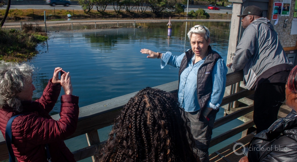
Circle of Blue reporter Brett Walton discussed groundwater-related flooding with Professor Hill following a community meeting in Marin City in February.
Brett Walton:
How did you get started working with Marin City?
Kristina Hill:
I was working on groundwater in relation to sea level rise already and then Terrie Green from Shore Up Marin City contacted me and asked me if I would work with them.
Brett Walton:
With groundwater and sea level rise, you’ve done most of your work on that issue in the Bay Area or elsewhere?
Kristina Hill:
We made the first map of depth to groundwater using State Water Board wells and we made it for the whole Bay Area. So we started at that big scale and now we’re looking for partners to work with in communities that we think are hotspots, where groundwater is going to rise.
Brett Walton:
How difficult was it to get the map together? Groundwater is a huge issue in California and mostly for agriculture and domestic drinking water purposes. But for flooding issues it had not been looked at before?
Kristina Hill:
No, because most people think of groundwater and they think we don’t have enough, because they associate it with the irrigation problems during the drought, that groundwater got drawn down really low by people using a lot of it for irrigation in the Central Valley and other places. But here within a couple of miles of the Bay shore and the ocean, on the open ocean coast, the groundwater is really shallow and it’s not the deep stuff that you would use for drinking water or irrigation. It’s the shallow stuff that’s only a few feet below the surface of the land, just loose in the soil, filling up pore spaces in the soil and it’s dirty because of runoff from streets and parking lots. So most people don’t think of it as a resource and it wasn’t mapped.
Brett Walton:
What got you interested in groundwater and flooding?
Kristina Hill:
The U.S. Geological Survey did a paper back in 2010, where they looked at flooding in New Haven, Connecticut and they modeled what’s going to happen to the groundwater as sea level rises. And that made everybody else start to think, because it showed impacts on the groundwater table as much as three miles inland from the ocean. So then I saw colleagues at University of Hawaii do a study of Honolulu and what their groundwater levels are likely to be as the ocean rises and they expect to have twice as much flooding in Honolulu as a result of rising groundwater than if you consider only seawater alone. So then I thought, well, we need to do something here in the Bay Area. And people had been talking about doing a groundwater map, kind of wringing their hands and saying, we don’t have enough money. And I knew that I could do it with some grad students for very little. So we use an available dataset, one that was already made available by the state and just interpolated a surface among all the well data points to approximate what the depth to groundwater is during a wet year near the coast. And that’s what we wanted to know.
Brett Walton:
So when do the effects start to show up for groundwater flooding? There are stages to this, right?
Kristina Hill:
The first step has already begun. I mean, we already see infiltration into open, cracked storm sewers and sanitary sewers around the whole Bay Area. And in fact, the East Bay is under a consent decree from the courts to remove infiltration from its pipes because when the storm sewer and the sanitary sewer is combined, that leads to overflow events of raw sewage into water bodies like the Bay. So they were already under a court order to remove that infiltration. And so it’s been tracked in some places and we can actually see that the amount of infiltration is increasing in some communities.
Brett Walton:
Then as you’ve done this research and discussed it with policymakers and public officials, what has been their response to it?
Kristina Hill:
Most people kind of look at me who are not coastal engineers and say, ‘Wow, well that makes a lot of sense and we need to get ready for that. We have to start thinking about it. What should we do?’ And when the coastal engineers hear about it, they think, ‘Oh, well, we’ll just pump.’ Because they’re aware of pumping as a strategy and that it gets used in high groundwater areas. But then I try to counter and respond that well, pumping on old wetland soils is going to cause subsidence. So we need to be careful about if and when we pump.
Brett Walton:
And that’s a particular issue here in the Bay Area where there’s a lot of construction on former wetlands, right?
Kristina Hill:
Yeah. This whole area, East Oakland, Foster City, lots of places in the Bay area are built on fill in the Bay. You can see the parking lot of the mall has subsided. And that’s all about the wetland soils subsiding and compacting with the weight of new development on top.
Brett Walton:
So then for Marin city, what are the effects that you’re seeing here? Short term, like immediate effects. And then, you know, 10, 20 years down the road?
Kristina Hill:
The engineers did a flood study to figure out why this area was flooding. And they thought that it was a combination of high tide and a rainstorm happening at the same time. And that does seem to be correlated with the flooding on the highway and only access in and out of Marin City. But the other piece of it is the water table, because as that rises, there’s less room in the soil for the rainwater to be absorbed by the soil. And so we’re seeing a kind of trifecta, like you get a high tide, you get a rainstorm and you get this higher groundwater and the flooding gets worse all the time. And then there’s been maintenance that hasn’t happened. And so pipes are clogged. So the lack of maintenance and these three other sources of water causing more flooding, in a bowl. And one of the reasons why I decided to work in Marin City was because you don’t have to make a sophisticated groundwater model to see what’s going to happen here. If it’s a bowl shape and the ground water rises, it’s not going to drain away. It’s just going to flood. In some place like East Oakland where there are drainage channels coming out, surface streams, groundwater is going to come up and it’s going to move towards those channels and out that way. So it won’t flood everywhere equally. It’s only going to flood near the tidal channels. But here it’s going to flood the whole bowl.
Brett Walton:
But that, that whole bowl flooding has not happened before. It’s in particular spots right now?
Kristina Hill:
It’s starting right at the edge of the mall and the highway and that’s where the community loses its access in and out at all. I mean, they really can’t get in and out of Marin City at all when that street floods.
Brett Walton:
How frequently do flood effects occur in Marin city?
Kristina Hill:
It depends on what you mean by a flood effect. Like high ground water table that’s driving some infiltration into sewer pipes and causing some of the subsidence and possibly generating mold: that’s every day, but the kind of flooding that prevents them from getting in and out of the community or that blocks the highway lanes. That happens every few years.
Eileen Wray-McCann: That was University of California, Berkeley professor Kristina Hill. She talked with Circle of Blue reporter Brett Walton about how rising seas affect groundwater levels in the San Francisco Bay Area. I’m Eileen Wray-McCann for Speaking of Water from Circle of Blue, your source for independent water news and analysis. Please visit us at circleofblue.org, where water speaks.
Brett writes about agriculture, energy, infrastructure, and the politics and economics of water in the United States. He also writes the Federal Water Tap, Circle of Blue’s weekly digest of U.S. government water news. He is the winner of two Society of Environmental Journalists reporting awards, one of the top honors in American environmental journalism: first place for explanatory reporting for a series on septic system pollution in the United States(2016) and third place for beat reporting in a small market (2014). He received the Sierra Club’s Distinguished Service Award in 2018. Brett lives in Seattle, where he hikes the mountains and bakes pies. Contact Brett Walton


